PAC3 Guide
Introduction
This is an example of the workflow a PAC3 study site might use to add geomarkers to their data with DeGAUSS.
If you have used DeGAUSS, would you mind providing us some feedback and completing a short survey?
In steps 2 through 6:
- A DeGAUSS container is used to add geomarker(s) to the input file (columns added in each step are highlighted in gray).
- The input file is the CSV created in the previous step, and the output file will be the input in the next step.
Step 0: Install Docker
See the Installing Docker webpage.
Note about Docker Settings:
After installing Docker, but before running containers, go to Docker Settings > Advanced and change memory to greater than 4000 MB (or 4 GiB)
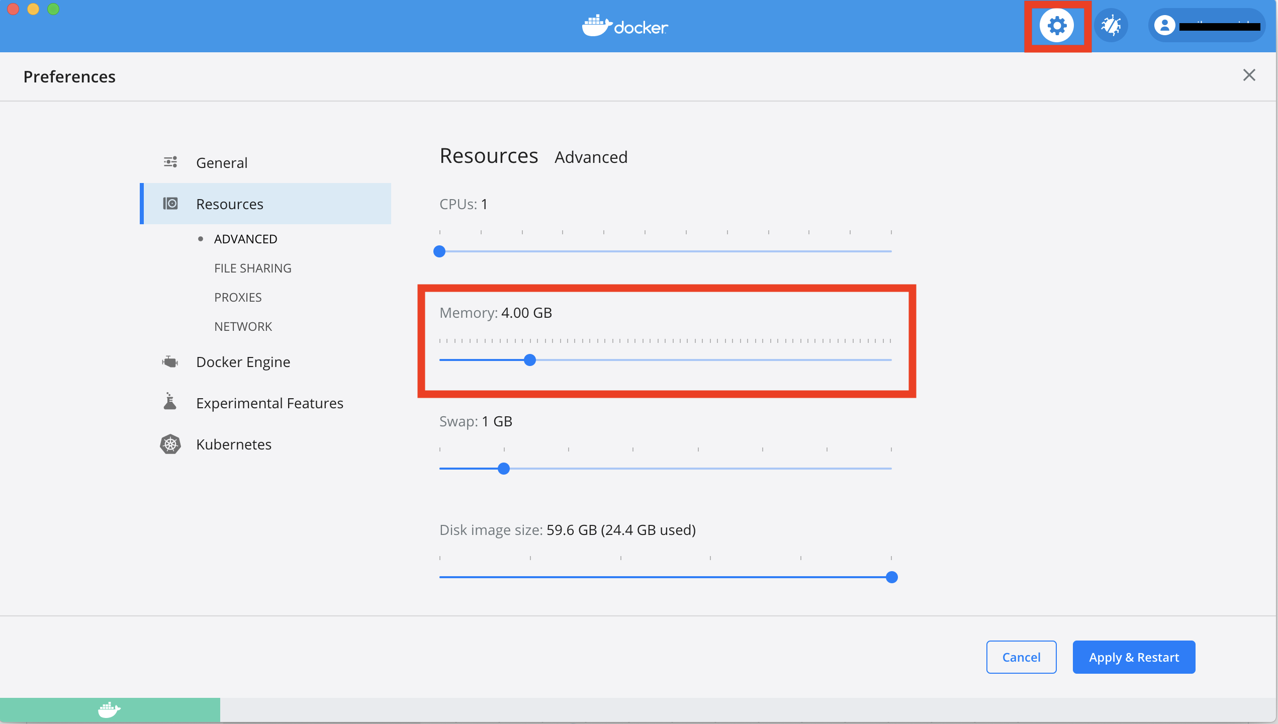
If you are using a Windows computer, also set CPUs to 1.
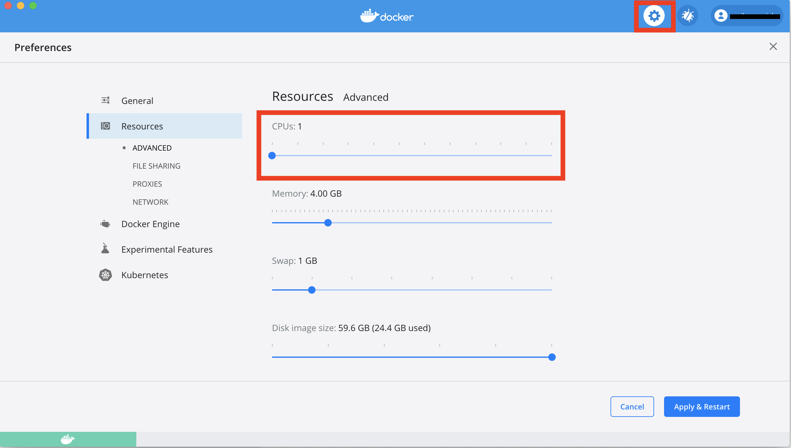
Click Apply and wait for Docker to restart.
Step 1: Preparing Your Input File
The input file must be a CSV file with one column called
address containing all address components. Other columns
may be present and will be returned in the output file, but should be
kept to a minimum to reduce file size.
An example input CSV file (called my_address_file.csv)
might look like:
| id | address |
|---|---|
| 13100070229 | 1922 CATALINA AV CINCINNATI, OH 45237 |
| 54000600136 | 5358 LILIBET CT DELHI TOWNSHIP, OH 45238 |
| 11200020024 | 630 GREENWOOD AV CINCINNATI, OH 45229 |
Refer to the DeGAUSS geocoding webpage for more information about the input file and address string formatting.
Step 3: Geocoding
After navigating to your working directory, use the ghcr.io/degauss-org/geocoder
to geocode your addresses.
macOS example call:
docker run --rm -v "$PWD":/tmp ghcr.io/degauss-org/geocoder:3.0.2 my_address_file.csvWindows (CMD) example call:
docker run --rm -v "%cd%":/tmp ghcr.io/degauss-org/geocoder:3.0.2 my_address_file.csvReplace my_address_file.csv with the name of the CSV
file to be geocoded and run the call in the shell.
Note for Windows Users:
In this and all following docker calls in this example, replace"$PWD"with"%cd%". Refer to the DeGAUSS Troubleshooting page for more information.
See here for more information on the anatomy of a degauss command.
The output file is written to the same directory and
in our example, will be called
my_address_file_geocoded_v3.0.2.csv.
Example output:
| id | address | start_date | end_date | matched_street | matched_zip | matched_city | matched_state | lat | lon | score | precision | geocode_result |
|---|---|---|---|---|---|---|---|---|---|---|---|---|
| 54000600136 | 5358 LILIBET CT DELHI TOWNSHIP OH 45238 | 2015-05-05 | 2015-05-06 | Lilibet Ct | 45238 | Delhi Hills | OH | 39.11552 | -84.61902 | 0.754 | range | geocoded |
| 13100070229 | 1922 CATALINA AV CINCINNATI OH 45237 | 2010-06-07 | 2010-06-08 | Catalina Ave | 45237 | Cincinnati | OH | 39.17112 | -84.46176 | 0.922 | range | geocoded |
| 11200020024 | 630 GREENWOOD AV CINCINNATI OH 45229 | 2019-07-08 | 2019-07-09 | Greenwood Ave | 45229 | Cincinnati | OH | 39.15321 | -84.49236 | 0.922 | range | geocoded |
For more information on interpreting geocoder output, see here.
Step 4: Deprivation Index
macOS example call:
docker run --rm -v "$PWD":/tmp ghcr.io/degauss-org/dep_index:0.1 my_address_file_geocoded_v3.0.2.csvWindows (CMD) example call:
docker run --rm -v "%cd%":/tmp ghcr.io/degauss-org/dep_index:0.1 my_address_file_geocoded_v3.0.2.csvReplace my_address_file_geocoded_v3.0.2.csv with the
name of the geocoded CSV file created in Step 3 and run.
The output file is written to the same directory
and, in our example, will be called
my_address_file_geocoded_v3.0.2_dep_index_v0.1.csv.
Example output:
| id | address | matched_street | matched_zip | matched_city | matched_state | lat | lon | score | precision | geocode_result | fips_tract_id | fraction_assisted_income | fraction_high_school_edu | median_income | fraction_no_health_ins | fraction_poverty | fraction_vacant_housing | dep_index |
|---|---|---|---|---|---|---|---|---|---|---|---|---|---|---|---|---|---|---|
| 54000600136 | 5358 LILIBET CT DELHI TOWNSHIP OH 45238 | Lilibet Ct | 45238 | Delhi Hills | OH | 39.11552 | -84.61902 | 0.754 | range | geocoded | 39061021303 | 0.0380034 | 0.9396114 | 83385 | 0.0236515 | 0.0250104 | 0.0128779 | 0.2087159 |
| 13100070229 | 1922 CATALINA AV CINCINNATI OH 45237 | Catalina Ave | 45237 | Cincinnati | OH | 39.17112 | -84.46176 | 0.922 | range | geocoded | 39061006300 | 0.1149033 | 0.8787645 | 38395 | 0.0391429 | 0.1641705 | 0.1284085 | 0.3569748 |
| 11200020024 | 630 GREENWOOD AV CINCINNATI OH 45229 | Greenwood Ave | 45229 | Cincinnati | OH | 39.15321 | -84.49236 | 0.922 | range | geocoded | 39061006800 | 0.3517316 | 0.8051400 | 19783 | 0.0579212 | 0.3901274 | 0.2309613 | 0.5527528 |
More information on the deprivation index
More information on the dep_index container
Step 5: Drive Time and Distance to Care Center
macOS example call:
docker run --rm -v "$PWD":/tmp ghcr.io/degauss-org/drivetime:1.3.0 my_address_file_geocoded_v3.0.2_dep_index_v0.1.csv cchmcWindows (CMD) example call:
docker run --rm -v "%cd%":/tmp ghcr.io/degauss-org/drivetime:1.3.0 my_address_file_geocoded_v3.0.2_dep_index_v0.1.csv cchmcReplace
my_address_file_geocoded_v3.0.2_dep_index_v0.1.csv with the
name of the CSV file created in Step 4, and replace cchmc
with the abbrevation for your care center from this list:
| center_name | abbreviation |
|---|---|
| Children’s Hospital of Philadelphia | chop |
| Riley Hospital for Children, Indiana University | riley |
| Seattle Children’s Hospital | seattle |
| Children’s Mercy Hospital | mercy |
| Emory University | emory |
| Johns Hopkins University | jhu |
| Cleveland Clinc | cc |
| Levine Children’s | levine |
| St. Louis Children’s Hospital | stl |
| Oregon Health and Science University | ohsu |
| University of Michigan Health System | umich |
| Children’s Hospital of Alabama | al |
| Cincinnati Children’s Hospital Medical Center - Main Campus | cchmc |
| Cincinnati Children’s Hospital Medical Center - Liberty Campus | liberty |
| Nationwide Children’s Hospital | nat |
| University of California, Los Angeles | ucla |
| Boston Children’s Hospital | bch |
| Medical College of Wisconsin | mcw |
| St. Jude’s Children’s Hospital | stj |
| Martha Eliot Health Center | mehc |
| Northwestern / Ann & Lurie Children’s Northwestern | nwu |
| Lurie Children’s Outpatient Center in Northbrook | lcclp |
| Lurie Children’s Outpatient Center in Lincoln Park | lcclp |
| Lurie Children’s Outpatient Center in Uptown | lccu |
| Dr. Lio’s and Dr. Aggarwal’s clinics | lac |
| Recruited from Eczema Expo 2018 | expo |
| University of California San Francisco Benioff Children’s Hospital | ucsf |
| Nicklaus Children’s Hospital | nicklaus |
| Medical University of South Carolina Children’s Hospital | musc |
| Children’s National Medical Center | cnmc |
| Children’s Hospital of Pittsburgh of UPMC | upmc |
| Methodist LeBonheur Children’s Hospital | methodist |
| Texas Children’s Hospital | texas |
| Arkansas Children’s Hospital | arkansas |
| Primary Children’s Medical Center | primary |
| Children’s Healthcare of Atlanta | atlanta |
| Children’s Medical Center of Dallas | dallas |
| Lucile Packard Children’s Hospital Stanford | packard |
| Toronto Hospital for Sick Children | toronto |
| Cook Children’s Medical Center | cook |
| Children’s Hospital & Medical Center - Omaha | omaha |
| Children’s Hospital Colorado | colorado |
| Arnold Palmer Hospital for Children | palmer |
| Children’s Hospital & Clinics of Minnesota | minn |
| University of Virginia Hospital | uva |
| Joe Dimaggio Children’s Hospital | dimaggio |
| Cohen Children’s Medical Center of New York at Northwell Health | cohen |
| Dell Children’s Medical Center of Central Texas | dell |
| A.I. duPont Hospital for Children | dupont |
| Rainbow Babies and Children’s Hospital | rainbow |
| UNC Hospitals Children’s Specialty Clinic | unc |
| Barbara Bush Children’s Hospital at Maine Medical | maine |
| Children’s Hospital of New Orleans | chnola |
| Rady Children’s Hospital | rady |
| Children’s Hospital Los Angeles | chla |
| Monroe Carell Jr. Children’s Hospital at Vanderbilt | vandy |
The output file is written to the same directory and
in our example, will be called
my_address_file_geocoded_v3.0.2_dep_index_v0.1_drivetime_1.3.0_cchmc.csv.
Example output:
| id | address | matched_street | matched_zip | matched_city | matched_state | lat | lon | score | precision | geocode_result | fips_tract_id | fraction_assisted_income | fraction_high_school_edu | median_income | fraction_no_health_ins | fraction_poverty | fraction_vacant_housing | dep_index | drive_time | distance |
|---|---|---|---|---|---|---|---|---|---|---|---|---|---|---|---|---|---|---|---|---|
| 54000600136 | 5358 LILIBET CT DELHI TOWNSHIP OH 45238 | Lilibet Ct | 45238 | Delhi Hills | OH | 39.11552 | -84.61902 | 0.754 | range | geocoded | 39061021303 | 0.0380034 | 0.9396114 | 83385 | 0.0236515 | 0.0250104 | 0.0128779 | 0.2087159 | 30 | 10219.326 |
| 13100070229 | 1922 CATALINA AV CINCINNATI OH 45237 | Catalina Ave | 45237 | Cincinnati | OH | 39.17112 | -84.46176 | 0.922 | range | geocoded | 39061006300 | 0.1149033 | 0.8787645 | 38395 | 0.0391429 | 0.1641705 | 0.1284085 | 0.3569748 | 18 | 5004.925 |
| 11200020024 | 630 GREENWOOD AV CINCINNATI OH 45229 | Greenwood Ave | 45229 | Cincinnati | OH | 39.15321 | -84.49236 | 0.922 | range | geocoded | 39061006800 | 0.3517316 | 0.8051400 | 19783 | 0.0579212 | 0.3901274 | 0.2309613 | 0.5527528 | 6 | 1755.939 |
More information on drivetime
Step 6: Removing PHI
Before sharing your data, remove the following columns:
addressmatched_streetmatched_citymatched_zipmatched_statelatlonfips_tract_id